
Christie Palmerston
Christie Palmerston and a mate, "W.L." thought to be William Layton, had spent several months searching for a suitable route from the Hodgkinson gold field through to the coast some 70 kilometres away 'as the crow flies' - this track led to a place described as "White Cliffs" near what was to become the site of Port Douglas. A road for wagons now opened the way to a new port in 1877.
Merchants from Cooktown and the fledgling settlement at Cairns rushed to the place to share in the bonanza to service the gold miners. In effect it was to bring most of the packers and teamsters to what the population of the now largely depleted Cairns called "that upstart Port Douglas" - a fierce struggle developed between the two towns for survival and bitter recrimination continued unabated with a government decision in 1882 for a railway survey.
On some expeditions, including work to assist with the railway preliminaries, Palmerston was often accompanied by a young Aborigine named Pompo who he said he had 'adopted' whilst exploring the headwaters of the Daintree River.
Palmerston, a.k.a. 'Christie', (c.1850–1897) was one of the foremost track finders in the North during this period of frontier expansion by Europeans into lands already inhabited by the first Aboriginal Australians.
The descent down into the Mowbray River valley was difficult for wagons and Christie's track had been quickly cleared by local subscription. A timely vote of funds by Queensland's government redeveloped the initial climb out of the valley on a spur slightly further west with an easier grade but teamsters still regularly needed to double-bank their straining teams up steep pinches like the less-than-affectionately named "Slatey" and "Blackguard".
Palmerston's Gap Road
Christie's track through the lowest gap between Baker's Blue Mountains and the granite range known as the Hann Tableland was part of the shortest route from Thornborough to the coast and down via the 'Bump' into the Mowbray River valley and on to Port Douglas.
In 1877 this south-western part of the Port Douglas road was originally used by teamsters and passenger coach drivers but very soon was generally abandoned in favour of a longer road around the southern end of the Hann Tableland because of unpredictable watering places for their animals. The packers with their horse and donkey teams continued to use the shorter route, saving time and cost.
The miners at the Hodgkinson goldfield which included the townships of Thornborough and Kingsborough had begun to clamour for a road for wheeled traffic when alluvial gold began to be worked out by early 1877.
A purse of £200 was offered to anyone who could find a shorter route than the hundreds of kilometres north to Cooktown or south to Georgetown - Christie set forth to find a suitable track over two mountain ranges to win that prize, but more importantly to allow heavy machinery to be brought in at less expense than formerly.
Herberton Railway Fight
The 1880 discovery of a rich tin field at Herberton initiated a request for a railway to the coast - Cairns and Port Douglas now locked horns in another round of fierce competition to be the coastal terminus.
Port Douglas residents suspected foul play on the part of the government towards favouring Cairns and denounced the railway department's two separate surveys for their own town. After protracted lobbying the Douglas Divisional Board contracted a surveyor for an alternative trial line as far as Groves' "Weatherboards" near the present day Mt. Molloy - the privately funded survey followed a route which was claimed to involve less engineering and cost than that needed up the Barron River valley out of Cairns - all to no avail when the decision was announced in 1884 in favour of Cairns.
Willoughby Hannam's Letter of Engagement of Christie Palmerston
Of note is the fact that Christie Palmerston's local track-finding experience was tapped by the government to show the railway surveyors all potential routes to ascend the ranges between Port Douglas and Mourilyan, south of Cairns. He was quoted as being "aghast" at the final route selection - see The Premier's Fairplay below.
When rail construction surmounted the range behind Cairns, Port Douglas lost its transport base and went into slow decline.
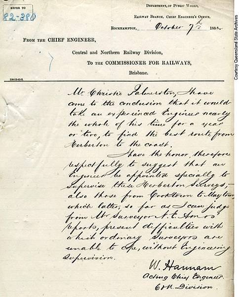
Excerpt of letter from Willoughby Hannam to Christie Palmerston
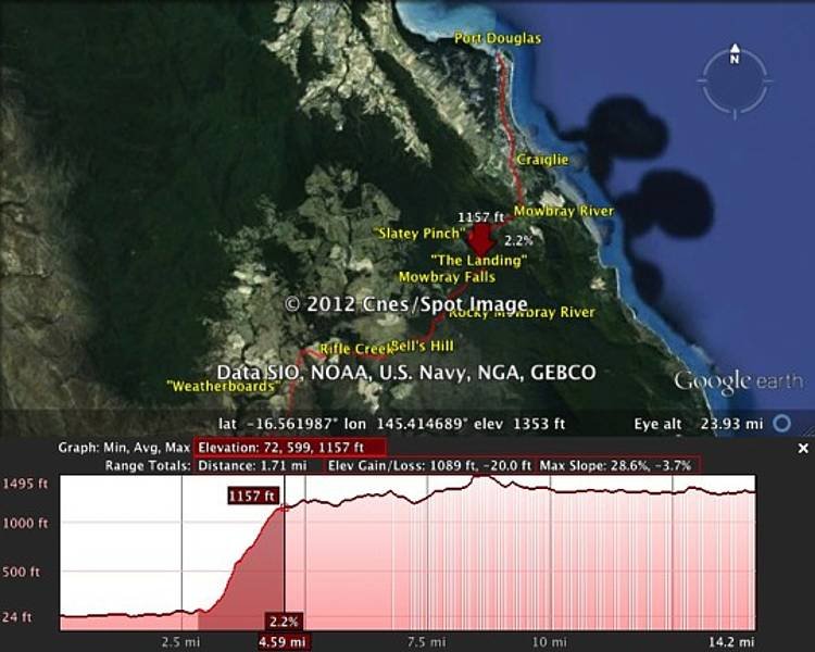
Bump Road elevation

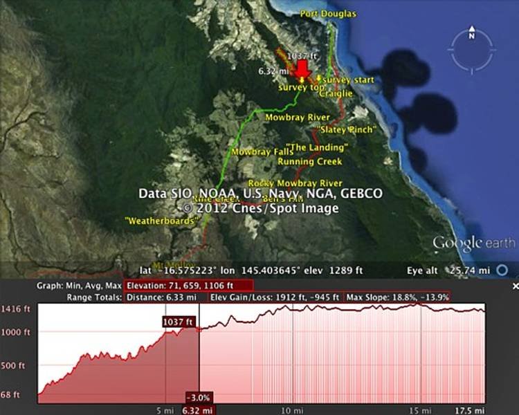
Gap Road elevation
Trailway elevation