The Bump Track
The Bump Track in North Queensland was the major track from Port Douglas to the Hodgkinson goldfields. Opened in 1877, it led to the establishment of Port Douglas, which operated as a key port in North Queensland for the Hodgkinson goldfield and Herberton tin field from 1877 until 1891.

In 1877 Christie Palmerston and William C Leyton were commissioned by Cooktown merchants to cut a track from the coast to the Palmer River and Thornborough gold fields. Palmerston was a prospector and explorer who undertook four commissioned expeditions in the region between 1877 and 1884. The track he discovered, which was to become known as the Bump Track, may have been an existing Aboriginal pathway. This road traversed the steep coastal ranges to the west of Port Douglas and provided a direct route between the Hodgkinson Goldfields to Port Douglas, via settlements at Mowbray River and Craiglie.
Palmerston and Leyton were rewarded for the discovery of the Bump Track with £200 from the grateful residents of Thornborough, which is located 70 km south west of Port Douglas. Mail services from Port Douglas to Thornborough commenced in December 1877.
Initially used as a pack track. In 1878, it was quickly upgraded to a dray and coach track. The journey between Port Douglas and Mowbray, at the base of the Bump Track, involved crossing the Mowbray River.
After an initial outlay of approximately £6000, a road was cut through the scrub, overseen by Government Road Engineer, A.C. MacMillan. Excavation was carried out by hand using picks and shovels, while holes for blasting powder were drilled into the rock with hand tools. By 1878, £2000 was spent improving the new road for wheeled vehicles. By 1880, 42 horse teamsters, 44 bullock teamsters and 29 packers were using the route. In addition, coach services also worked the track, and by September1882, Cobb and Co operated a weekly service until 1892 and twice weekly until 1904.
Gold escorts also used the track and heavy machinery was hauled up from coastal steamers to the hinterland copper and tin mines by bullock and horse teams struggling up the steep rise. Coming down, they tied a log on the back to stop them slipping.
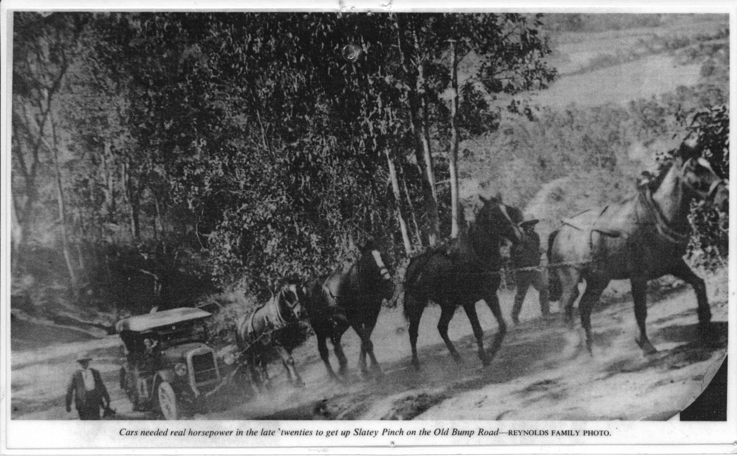
From Port Douglas the coach service route went via Four Mile Beach to Craiglie and then via the Mowbray Valley to the foot of the range where the current Bump Track begins. The first ascent was up a steep straight ridge, which was replaced in 1879 by the route that is still in use today. The new route required cuts through the ridge at a point known as ‘Slatey Pinch’. Above ‘Slatey Pinch’ the grade eased and levelled at an area at the top of the range known as the ‘Landing’. There were steep approaches to Robbins or Running Creek, which was spanned by a timber bridge, the bed logs of which were bolted to the bedrock in the creek. The ‘Glue Pot’ was another obstacle on the track, but has since been filled in. Near the junction of the Bump Track and Black Mountain Road, Jack Allen ran a Cobb & Co. staging post. Further north, Reynolds Hotel was located near the ford through Rocky Mowbray Creek, from where the track proceeded over the top of the range at Bells Hill and then onto Mt Molloy, Mareeba, Herberton and Thornborough.
The main features:
• Slatey Pinch: a cutting approximately 200m long with a steep sheer rocky face 4m to 6m high on the western side of the track.
• The Junction: where the original path branches off the east side of the existing route. The side of this bench is 1.5m high and the path is approximately 5m wide. Its relatively shallow cut into the ridge is in contrast to the deep cuttings on the existing track.
• The Landing: at the top of the climb up and extends for at least 60m along the western side of the track and between 30m and 100m west from the track. A few scattered glass jars and a fallen timber telephone pole with galvanised steel fittings are located here.
• Running or Robbin’s Creek Bridge: structural bridge timbers along the banks on both sides of the creek for 50m up and downstream from the crossing. Some of the timbers contain metal bolts and brackets and some are still bolted together. The earthen and timber retained abutment or foundation for the bridge remains on the southern bank of the creek. To provide for its current use as a walking / horse riding / mountain bike track a 1m to 2m wide metal ramp on the northern bank and a similar width concrete and rock ramp on the southern bank have been constructed down the steep banks to the edge of the creek.
• Other: Two isolated timber poles, one steel pole and two mango trees are found in isolated locations beside the track between Connolly Road and Robbins Creek.
The Bump Track remained the main route from the coast to the Hodgkinson until the Cairns to Mareeba railway opened in 1893. This development meant Cairns became Far North Queensland’s premier port, and significantly altered business and trading in Port Douglas. Despite the advent of rail, the Bump Track remained the main access road from the coast (Cairns and Port Douglas) to the Tablelands until 1926 when the Gillies Highway was opened.
When cars were introduced, sometimes they had to be hauled up by horses.
The Cook Highway from Cairns to Mossman via Port Douglas opened in 1933 so the Bump Track was only needed to access the Tablelands.
The track was still considered sufficiently important during World War II to be mined so that it could be destroyed in the event of a Japanese invasion.
The opening of a road from Mossman to Mt Molloy during the war further reduced the use of the Bump Track to becoming a service route for the telephone line.
After the telephone line was re-routed in 1953, the track was only kept open by four wheel drive groups, horse trail riders and trail bike riders.
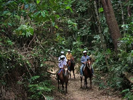
In 1988 the Bump Track came under the management of the Queensland Parks and Wildlife Service. It has been upgraded in recent years and is now a popular walking and mountain bike trail.

According to a local historian, Diggers’ Bridge was built over the Mowbray River by returned soldiers for the Douglas Shire Council. No date of completion can be found but it was finished by 1923. A new bridge was built in mid 1940 to the eastern downstream side of the original bridge. In 2010, the girders and the transom were replaced.
A third bridge was completed in 2019 by Douglas Shire Council. The 1940 wooden structure became a pedestrian bridge and an original pile from the first bridge is displayed at Teamsters Park in Craiglie.
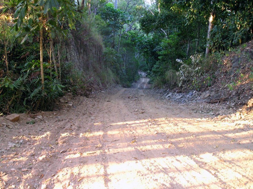
Slatey Pinch in contemporary times

Mowbray River